CHAPTER 18: Hawaii

Geology

North view from the Prudential Building
(the tallest building)

The Boston's Prudential Building top view provides a geological history of the city. From the top of the building, visitors can see the remnants of exploding volcanoes, glacial debris, and colliding continents. The Wisconsin Ice Sheet, the last glacier to cover New England, formed Cape Cod and the islands of Martha's Vineyard and Nantucket. Around Boston, the glacier left dozens of drumlins and bowl-shaped hollows which formed most of the ponds of Boston’s Emerald Necklace, a chain of parks and parkways.


Middlesex Fells


a cliff in the Middlesex Fells Reservation


At the Middlesex Fells Reservation, aka the “Fells,” a Metropolitan Park System of Greater Boston, many can hike or mountain bike among 630-million-year-old volcanic rocks. The reservation comprised of 2,060 acres of wetlands and oak forests.

16 kilometers up the coast from the Fells is Castle Rock in Marblehead Neck, a favorite field trip of geology classes and rock climbers due to its interesting "swirled" texture. The 600-million-year-old volcanic rock was the remnant of the explosive volcanoes that once dominated the Boston area, before they eroded away. In addition, the Squaw Rock Park, just south of downtown Boston, offers a look at some 570-million-year-old rocks, which some researchers thought were deposited during the ice age period. These ancient sedimentary rocks can be found along the park's small northern beach, and offers an exquisite view of Boston Harbor and the Boston skyline.


Squaw Rock Park


“Swirling” rocks found in Castle Rock in Marblehead Neck


CHAPTER 16: The North Pacific Coast

Power and Dams

Charles River with Longfellow Bridge crossing over it

In the 19th century, the Charles River was one of the most industrialized areas in the United States and its hydropower soon fueled many mills and factories. By the century's end, 20 dams had been built across the river, mostly to generate power for industry. An 1875 government report listed 43 mills along the 9.5-mile (15 km) tidal estuary from Watertown Dam to Boston Harbor.

Charles River Dam


A lock on Charles River Dam

The Charles River Dam, built in 1978, controls the water level in the river basin. An earlier dam, the Charles River Dam Bridge, was completed in 1910 with the purpose of creating a fresh water river basin and riverfront park in Boston. The newly landscaped banks of the river became known as the Charles River Esplanade. The modern dam, has six pumps that provide flood control protection. The dam's lock system permits travel of recreational and commercial vessels from the river to the harbor year round. A fish ladder allows for passage of anadromous fishes, such as alewife, rainbow smelt, and shad during the migration season in late spring.

The purpose of the new dam is to control the surface level of the river basin, as well its contributing surfaces upstream, such as The Back Bay Fens and Muddy River. It also prevents sea water from entering the Charles River freshwater basin during high tides. The previous dam's one lock is now kept open for navigation. The older dam could not keep sea water out and a layer of salt water accumulated at the bottom of the fresh water basin, contributing to pollution and fish migration problems.


CHAPTER 15: California

Water Supply

Quabbin Reservoir


Wachusetts Reservoir at sunrise


Where does Boston's drinking water come from?

Two source reservoirs in central and western Massachusetts: the Quabbin and the Wachusetts Reservoirs. In addition to the reservoirs, the system includes surface aqueducts, covered storage tanks, treatment facilities and deep rock tunnels. This system is known as the Metropolitan Boston Water System. The Massachusetts Water Resources Authority (MWRA) and the Department of Conservation and Recreation (DCR) jointly manage the Metropolitan Boston Water System.
As mentioned from my previous post, MWRA provides treatment and distribution of drinking water to 50 communities in the metropolitan area, including Boston. The DCR manages the lands adjacent to the source reservoirs and is responsible for keeping the reservoirs free from water quality contamination to the greatest extent possible. Lastly, Boston Water and Sewer Commission (BWSC) delivers the water to homes and businesses throughout the City of Boston.
The Quabbin and Wachusetts combined, supplied an average of 214 mgd (millions of gallon a day) to consumers in 2007. The safe yield of the reservoir system is 320 mgd. Treatment of the water includes ozone disinfection, pH adjustment with sodium bicarbonate, and the addition of chloramines and fluoride. Water leaves the plant through the Metrowest Water Supply Tunnel and is stored in covered storage tanks.

Sources:


CHAPTER 14: The Southwest Border Area: Tricultural Development

Racial and Ethnic Diversity in Boston

The Immigrant Landing Station at Boston circa 1904

Steamship lines served the United States exceptional inducements to bring through immigrant passengers to places, such as Boston. These inducements were: a shorter ocean voyage; an inland rate of $1.00 to the West; and free piers in Boston with spacious quarters for handling immigrants.

Boston Immigrant Landing Station

Recently arrived immigrants entering the United States through the Port of Boston (1904)
Currently...
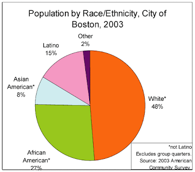
Boston has grown by 2.6% over the 1990s because of immigrants. As of the 2000 US Census, more than half the population of the City of Boston consisted of African-Americans, Asian-Americans, and Latinos. Boston’s young people tend to be even more racially and culturally diverse than older residents.  For example, as of the 2000 US Census, 75% of Boston’s residents between the ages of 14 and 17, the young adults of the next decade, were African Americans, Asian Americans, or Latinos.

More than one-quarter of Bostonians were foreign born, the highest rate since 1940. About 337,000 immigrants arrived in Massachusetts in the 1990s alone, accounting for 82% of the net growth in the labor force and making up 45% of the state’s blue-collar workforce, 27% of service employees, 14% of professionals and 10% of managers and executives, according to a study by the Center for Labor Market Studies at Northeastern University.


CHAPTER 13: The Empty Interior

The Mormon Presence

Boston Massachusetts Mormon Temple


Standing atop a wooded granite hillside in the northwest suburb of Belmont, the Boston Massachusetts Temple, the first temple built in New England, is a striking landmark along the busy Concord Turnpike.

It is the home to the church's most prominent member: Gov. Mitt Romney, Boston Celtics president of basketball operations, Danny Ainge, and several noted academics, including Pulitzer Prize-winning Harvard history professor Laurel Ulrich.

A Brief History...

Boston was home to a 400-member Mormon congregation in the mid-1800s, the largest in the eastern United States at the time. However, it disbanded shortly after the slaying of founder Joseph Smith in 1844, when Mormons fled widespread persecution with a mass migration to the valley of the Great Salt Lake.

After a century later, Mormons returned in notable numbers to Massachusetts in the 1960s. Mormons have also pushed evangelization in immigrant communities. About 140 Mormon missionaries work daily in Massachusetts, spreading the faith through street evangelism and door-to-door visits.

Between 1994 and 2004, Massachusetts membership in The Church of Jesus Christ of Latter-day Saints increased 56%, from 14,840 to 23,161. A small amount, compared to the state's 3 million-member Catholic church. But it approaches the 33,400 state members of the Unitarian Universalist Association, whose roots in Massachusetts go back to the 18th century.

To view more of the Boston Massachusetts Mormon Temple, click here .

Sources:

CHAPTER 12: The Great Plains and Prairies

Funnel cloud over Boston area
Extreme Weather

Like the Great Plains, Boston also experiences extreme weather condition. Fog is prevalent, especially in spring and early summer, and the occasional tropical storm or hurricane can threaten the region, particularly in early autumn. The city is often subjected to sea breeze because of its location along the North Atlantic, that occurs during the late spring when water temperatures are still quite cold and temperatures at the coast can be more than 20 °F (11 °C) colder than a few miles inland, sometimes dropping by that amount near midday. From May to September, the city experiences thunderstorms that are occasionally severe. In addition, large hail, damaging winds and heavy downpours accompany such severe events. Although downtown Boston has never been struck by a violent tornado, the city itself has had many tornado warnings.
Tornado Facts: Boston
Peak tornado month: July
Total tornadoes since 1950: 26
Strongest tornado: F3, September 29, 1974 (Middlesex County)
Click here to see a lightning storm over Boston
Deer Island
Waste Water Treatment

Water is an important resource in the Great Plains, and since this chapter talks about water control and irrigation, I thought it would be interesting to include Boston’s Deer Island Waste Water Treatment Plant. Deer Island has its own rich and tragic history. It served as an internment island for Native Americans (1675-76), a holding area for Irish immigrants fleeing the Great Famine (1800s), a major hospital (1847), and a prison (c. 1882-1988). Nowadays, the island is known for its natural resource protection, the home for Deer Island Waste Treatment Plant with its egg-like sludge digesters that serve as major harbor landmarks.

Egg-like sludge digesters

This sewage treatment plant is run and operated by the Massachusetts Water Resources Authority. The water treatment plant cost over 3.8 billion dollars, making it the seventeenth most expensive object ever constructed. The plant began operating in 1995 and is considered the second largest sewage treatment plant in the US. The plant removes human, household, business and industrial pollutants from wastewater that originates in homes and businesses in forty three greater Boston communities.

Sources:
http://en.wikipedia.org/wiki/Boston

http://en.wikipedia.org/wiki/Deer_Island_Waste_Water_Treatment_Plant